The article below was the first I'd heard of a Wireless Station in Dogsthorpe. But with the wonders of Google I found a book "Probing the Sky with Radio Waves" by Cheng Pang Yeang. This told me that Dr Appleton had persuaded authorities to convert a disused wartime wireless direction-finding base into a radio research centre with receiving apparatuses.
I'd be very interested to know where in Dogsthorpe the Wireless Station was, but I don't suppose it will be on a map - I was wrong, from the guest book, thanks Michelle..
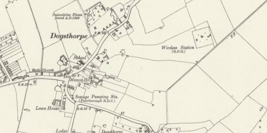
03/11/2015Michelle Horne Dogsthorpe Wireless Station is shown on the 1926 1:25000 scale Ordnance Survey map. it lay within the grounds of the John Mansfield School
John Crunkorns book Memories of Dogsthorpe is a mine of information, and I found this:
"A public footpath followed the line of what is now Central Avenue as far as the railway crossing. Approximately halfway along this path was a small brick building used as a radio relay station."
The footpath can be seen on the 1950s map starting at this time by the new school and marked F.P.
Thanks to Patrick for this information he added to the Guestbook
25/04/2016Patrick Stanbridge
My father, Arthur Stanbridge (1893-1938) was a GPO wireless operator who, although technically in the Royal Engineers signal service, spent much of WW1 posted to Dogsthorpe wireless station as a civilian. Sadly he died when I was young and all I know about his work there is what Sir Edward Appleton said about it together with two War Office letters (in 1916 and 1919) addressed to staff of the "special wireless stations" for their confidential work about which (1916) secrecy was required. Was Dogsthorpe part of an early-day Bletchley Park operation?
Not quite, I think!
Dad married my Mum in Peterborough in March 1916 when his address was 15 Seargeant St, Peterborough. After marriage, the couple stayed for a few months with a Mrs Twelvetree in Dogsthorpe before moving to Peterborough. At the end of the war Dad was at Seaham Harbour wireless station, co. Durham.
See more about the Twelvetrees in
Methodist Chapels
The use of radio direction finding dates back to World War I, when both the Allies and the forces of the Central Powers used it to locate enemy positions on the ground. The essential principles of direction-finding were established at that time, well before radio entered commercial use in the early 1920s.
This photo of Garton End Rd show what I believe to be the aerial in the background.
.jpg)
17th November 1933 Press cutting.